This practical guide takes readers to the best trails found in the Great Trinity Forest, all within easy reach of Downtown Dallas. Destinations include less traveled, low-traffic areas for hiking, mountain biking and horseback riding in the City of Dallas. Joppa Preserve, McCommas Bluff Preserve, Trinity River Wetlands, Texas Horse Park, Dallas Trinity Paddling Trail, Lower White Rock Creek, Sycamore Dixon, Texas Buckeye Trail, Dallas Whitewater Wave, Levee Trails, Rochester Park and more.
Swamp Coyotes in the Great Trinity Forest dawn June 23, 2012
Staring down three coyotes at 6:00 on a summer saturday morning among a labyrinth of head high swamp grass is quite a way to start a day. I could not tell if they were interested in me or the beeps of my camera. More photos mean more beeps which brought them in closer and closer. Uncomfortable to the point where I started to wonder whether or not they were curious or hatching a game plan to eat my camera for breakfast. Since it was technically nautical twilight they might have been wrapping up a long night of hunting before calling it a day.
They are the swamp coyotes. An elusive and fleet footed pack that roam the oxbows, ponds and swamps along the Trinity River. Very hard to see since they run among the reeds and willows that surround the old meanders of the river. It's not the sight of this pack that is exciting rather their liberal use of vocal calls. Since they cannot see one another in this swamp country they call to each other constantly. Many times, I have been in this same spot only to be surrounded by yipping and calling coyotes. A little unnerving but fun. Healthy adult coyotes pose no real threat to adult humans and attacks are very rare to non-existent. This pack in particular are true ghosts. They will often howl and call from areas where you just walked, as if they were following you. The coyote pack in the photos here worked their way behind me then stood their ground for some time before melting back into the swamp grass.
Wading through the swamp is no small feat. The high grass and marshy peat bottom make for a tough go before sunrise. The reward is catching a glimpse into a world few people see.
White Ibis in the pre-dawn light
Wood duck mother with her young and two Great Blue Herons
Black Necked Stilts
Snowy Egret
Little Blue Heron
Sunrise Through The Eye Of A Green Tree Frog
The photo above and below are opposing views 180 degrees of the sun as it climbs above the tallest grove of trees in Dallas. Seen first through the reflection of an American Green Tree Frog's eye.
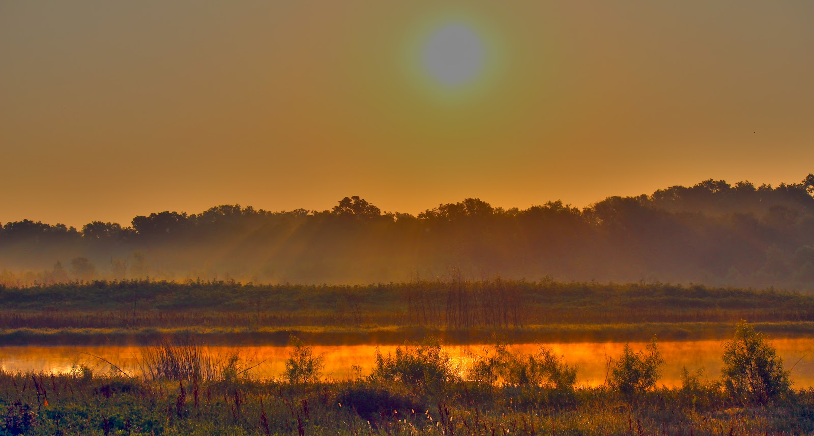
Sunrise over the foggy Dallas Trinity swamps June 23, 2012
These frogs really crank up their calls after sunset. Hard to carry on a conversation they are so loud.
American Green Tree Frog Hyla cinerea in the Great Trinity Forest
If you have a pair of 3d glasses(red/cyan) anaglyph check out the 3d photo below of the tree frog. 3d works well in reeds like this as they give a depth of field. Coupled with a stationary subject like the frog and no wind, it was a good time to setup a shot using multiple exposures. The photo can be "clicked on" to enlarge.
A story older than Texas itself. One that has been told and retold countless times in English, Spanish, French, Comanche and Caddo. A story told in those languages at the very spot seen above over two dozen centuries. The fight over water. You don't realize how valuable water can be until you don't have it or someone else wants yours. Water. The good stuff.
Jim Flood, Bill Holston, Scott Hudson at White Rock Spring June 9, 2012
Cliff Notes: Sadly, the historic Big Spring has become threatened. One of the few remaining natural springs left in Dallas, it is a priceless treasure. A commercial business started illegally drawing water off the spring using a hose and pump for their operations. The spring became impaired as a result. I became aware of the situation shortly after Memorial Day and after I pulled myself off the ceiling in anger, I started asking around who could help. That help came by way of the most well known concerned private citizens familiar with the Great Trinity Forest. Master Naturalists, authors, scientists and professionals in their chosen field. Jim Flood, Bill Holston, Dr Tim Dalbey and Scott Hudson. If you could ever assemble a blue ribbon group of experts on the Trinity River, this would be it. To have them all gather in one spot on a Saturday to discuss the plight of the spring is exceptional and underscores the seriousness of the situation.
Scott Hudson and Dr Tim Dalbey taking field notes at an ancient Indian site
Back story: The story to protect this spring, White Rock aka Big Spring, Sam Houston's Spring, Pemberton's Spring, is not a new
one. Tucked into a terrace just above the Trinity River floodplain the
spring has faced challenges before. Flooding, commercial gravel
operations, sewer lines and utility right of ways all have threatened
the spring. Voices of reason stepped forward and saved it. In this very
spot man has fought for the spring. With sticks, then arrowheads, then
musket, then rifle and now the preferred weapon...email. Each fight as
serious as the last. Only the faces and weapons change. Man has been drawn to this spring for centuries. Stone tool pieces from Native Americans are underfoot at every step around the spring. Subject of archeological surveys, countless artifacts turn up with every new search.
Illegal sump box and pump hose at the spring
A big hats off and thank you to the city attorney's office and especially the Trinity Watershed Management office who put a halt to some of this in short order. I think that there are a couple special people working in the offices there that worked quickly to resolve the illegal pumping. I'm afraid though that this is just the first inning of a nine inning game to protect the spring. With rumors of a well that might be dug up the terrace, coupled with past poor land stewardship by the business, the threat to the spring is just beginning. Read on and I'll get to that.
The spring itself is part of what geologists call a perched aquifer. The spring sits on a slope overlooking the Great Trinity Forest. Above the springs is a sandy gravel some 30 feet or more thick. Water percolates through this strata with ease. Where the sand and gravel contact an impervious layer of bedrock water flows horizontally till it reaches the spring site.
One threat to a perched aquifer and spring such as this is the pollution at ground level that can easily enter the water. Poor land practices, drilling and surface contamination can sour a spring like this in days. There is a good reason to worry this might happen to this spring. Like I said above, read on and I'll get to that.
The water in the spring is crystal clear. Home to minnows, crawfish and the random turtle, the spring serves as a year round water supply for local wildlife.
The provenance showing title ownership of the land here can counted using the fingers of one human hand. 500 years back. John Beeman in the 1840s was the first pioneer to patent and own this
land. His oldest daughter Margaret Beeman inherited this property along
with her husband John Neely Bryan, founder of Dallas. Here they built a
home near the spring and raised a family. Margaret Beeman eventually
sold the land to Edward Case Pemberton in the 1880s. Edward Case
Pemberton operated a dairy farm at this location and also ran a small
store just down the road. He was murdered at his store in 1914. The land
was inherited by his seven sons. Today the spring portion of the
property is owned by the City of Dallas. Now part of a larger parcel of land known as the Great Trinity Forest at some point in the future this site will be integral into telling the history of Dallas. North Texas is often overshadowed in Texas lore by the great Spanish Missions of San Antonio or Indian battles of the west. This spring site holds a place among those missions, battlefields and unique land features. It's a history that is largely unwritten and waiting to be discovered.
The spring is a special place. I wish more people could visit, learn about the rich history behind it and drink straight from the source. It's a cold sweet water even on a hot day. Within minutes at the spring site, everyone who visits realizes that it should be left in a natural state. No fancy concrete trails, picnic tables or landscaping would make it better. Just leave it be. Seems simple enough.
The spring has undergone a number of name changes over the years. Called
White Rock Spring by the Sam Houston treaty party, then noted as Big
Spring on Civil War era maps. Later called Bryan's Spring and Sam
Houston's Spring. I'm not sure what it might be officially called. It is
not labeled on contemporary USGS topographical maps or noted in the Springs of Texas by Gunnar M. Brune. Springs of Texas
is the encyclopedic reference to locating many of the natural springs
in the state. For whatever reason, this one was missed. It could be that
during the writing of the book in the 1930s, that the springs were
forgotten, hidden away on the back side of a dairy farm. Since the land
has always been closely held among just a handful of families, the
location might not have been known.
President Sam Houston and His Treaty Party
SamHouston's
last term as President were filled with heavyweight issues. His highlighted concerns were Indian relations, war on the horizon with Mexico
and Texas annexation into the United States.
He had lived with the Cherokee people for years as a young
man, had a fondness for the tribes and wanted them treated fairly as
their lands were taken over by civilization despite their
depredations against the settlers in Texas.For months Houstonsent
messages to his Indian friends proclaiming he would hold a Grand
Council of the Tribes at Fort Bird(presently in the Mid Cities area)
during the full moon of August 1843. Similar to what we might consider a
general assembly meeting of the United Nations. Houston sent Indian
Commissioner Joseph C. Eldridge out months in advance of the date to
bring the Comanches and others to the treaty council.It
was in August 1843 when Sam Houston and an expedition of about 30 men
departed Crockett in East Texas, and began their trek to the Three
Forks of the Trinity to negotiate with the chiefs of the Indian
tribes. Their route was well documented traveling roughly on the same
route into Dallas that US Highway 175 takes today. This route was an
ancient Pre-Columbian trail used by Indians for many centuries as an
important trade route between the Piney Woods of East Texas, the Plains
and Indians living north of the Red River. Scyene and Preston Roads
share similar distinctions in Dallas as ancient Indian trails that
later became major roads.
One of the
men in his group was an Englishman by the name of Edward Parkinson. He
kept a detailed account of the trip in his diary. It's believed he came
along just for the adventure of seeing real live Indians on the plains.
At the time the Beeman family was still living in a blockhouse near
present day Dolphin Road and Military Parkway. The account below
mentions that they did not see the Beeman family until the next morning.
This is because the Beeman family had not moved. There was a mix up in
the titleholders of property back then. The land they originally settled
was actually already claimed by someone else. The moved to the spring
site shortly thereafter.
"We
encamped that night at White Rock Springs, so called from the
calcareous nature of the rocks abundant here about one mile from the
White Rock Fork of the Trinity. In the morning some settlers from the
infant colony opened about the Forks of the Trinity River visited us,
accompanied by some travelers examining the country, they brought us no
news of the expected Indians and were on foot, stating that some little
time previous the wild Indians had stolen all the horses but one or two
belonging to the settlement.
We
then saddled up and proceeded to the fork at White Rock Creek which we
found very difficult from the rain which had fallen making the bank on
the other side one slide of about thirty feet, from top to bottom. We
were obliged to dismount and drive the animals over, some of them
describing curious mathematical figures, from their inexperience in the
science of sliding. However, all got over safe, and on reaching the
prairie on the other side arrived at one of the colonist’s cabins{that
of John Beeman} where we were regaled with an acceptable and plentiful
supply of buttermilk. My horse(a mustang) having become almost knocked
up, I determined upon resting here, and was hospitably entertained until
the following day, the company in the meantime moving on to Cedar
Springs, where they rested a day or two previous to marching on to
Bird’s Fort on the West Fork of the Trinity the appointed Treaty Ground,
great anxiety prevailing respecting the Indians but no news of
them."--Edward Parkinson 1843
Jump to 2012
Bill Holston with a mouthful of spring water
Our own visit to the spring 169 summers after Sam Houston, was to see first hand what was going on there, what could be done and getting a brief inventory of the trees, water quality and observable artifacts. Plus some general screwing around too.
Scott, Tim and Billy Ray talking about something -this- big
Tim and Scott measuring the Bur Oak
Dr Dalbey brought along a number of things with which to measure and document. One was a tape measure to get a size on the very old and very large Bur Oak next to the spring. At 11 feet 9 inches or 141 inches it stands as a giant among other trees in the vicinity and would be considered large for its species. There are larger Bur Oaks that pepper DFW but few with such a history. Absolute miracle this tree stands here.
Walnut Tree at the spring with a spike driven in it noting the highwater mark of the 1908 flood
A water sample was also taken for independent analysis to establish not only the water quality but also to serve as a baseline for the future. I have drank freely from the spring numerous times and I hope to continue to do so. It's 55ish degrees year round and tastes sweet.
Part of our trip was exploring the known and unknown Native American sites between White Rock Spring and the future Texas Horse Park. On the terraces above the spring evidence of ancient man once littered the ground. These areas were reduced by Depression era gravel mining in the 1930s. Still, some pockets of untouched Indian camps and arrowhead making sites exist today. We took a brief walk following the old terrace contours to the south while Dr Dalbey an archeologist took heavy field notes on what he saw.
Wandering to the Horse Park
Untouched prairie in the powerline right of way between the spring complex and the Horse Park
I guess to grasp what we saw at the Horse Park, it needs to be divided up into three categories. First, the ancient Indian terraces, camps and remains that are visible on the ground. Second, the historic structures of the old farmsteads and buildings dating back from the turn of the last century. Finally, the contemporary structures and the issues surrounding them.
The Ancient Native American Sites And Fossils
Dr Dalbey holding a piece of worked chert
To my untrained eye, I could not see what we were standing on was an old tool making spot for Native Americans. The hammered off pieces of chert flakes, the burnt limestone rocks of ancient campfires covered an area on the terrace. The dirt road nearby had worked flakes, where someone had sat and chipped arrowheads and tools into hunting implements. Much of this area has never been studied in detail and sits in the footprint of some future Texas Horse Park buildings. Hopefully it can be studied in great detail before the clearing begins for construction.
I cannot underscore the dismay we all felt when Dr Dalbey said that some of the terraces, the ones with the most artifacts were destroyed recently by bulldozing and grading by the previous tenant. Now buried under many feet of building debris and slaughterhouse refuse, the Native American site listed as a possible candidate for inclusion on the National Register of Historic Places is gone forever. To untangle that mess of discarded animal fat, bones and just trash might not be worth the effort. Would it shock you to learn that the same business responsible for that is the same one sucking water from the spring?
The other issue is the unique fossil record underlying the soil here. Like a Dallas version of the La Brea tar pits, this piece of land has yielded dozens of mammoth skeletons over the last one hundred years. It's a certainty that more lie below the ground here.
The Discovery Channel even produced a television show on the mammoths found in this part of Texas called Prehistoric Dallas.
The show discusses in some detail how the mammoths ended up in these sandy gravels and soils. At the time they wandered over Dallas, the area was a flat river plain. The salts and minerals probably attracted these cousins of modern day elephants. Whether through quick sand, predators or drowning they died by the dozens between Lake June and Loop 12. Mixed in are bones of now extinct ancient antelope, camels, bears and large cat species that preyed on all of them. Many of the finest examples of mammoth skeletons now found in museums worldwide came out of the area in and around the Texas Horse Park.
The Historic Era 1800s-1950s
Wallace Jenkins era maintenance shed and work bays
The old farm that once sat here was known in the communities of Pleasant Grove and Elam as the Kirby Farm. Some of it might still be here dating back to the Civil War Era. It's hard to look at some of the old cabin foundations and wooden structures to place an age on how long ago it might have been built. Some are much older than others. The more substantial buildings were built post 1938 when a man named Wallace Jenkins owned the property. Mr Jenkins built some really nice structures on the property, including a set of dams for a creek, maintenance buildings, a cattle loading dock and ranch headquarters.
Ranch building possibly a residental home for a caretaker or a ranch office
The old dilapidated building you see above probably at one time would have been a nice place. A poured concrete front porch facing south with double french doors it would have made for a nice residence or office on the ranch. Overlooking the ranch headquarters for the Jenkins property, Billy Ray Pemberton believes it was built in the 1940s.
The Jenkins structures have for better or worse stood the test of time. Were it not for all the recent lack of maintenance they might have been salvaged into part of the Horse Park.
Contemporary Structures--if you can call them that
Panorama of some buildings at the 811 property (click to make larger)
Hard to get a grip on what has probably been going on there recently. The standing Jenkins Farm structures of decades ago in some cases have been refitted to serve other purposes while "newer" structures stand in their own new footprint. The newer construction does not feature a single structure, piece of plumbing or electrical work that looks up to code. Not one. I wonder how this was allowed to happen. It sits on city owned property and the previous tenant rented the land. The mess left behind is just epic in destruction.
Understand this was used a commercial animal slaughter facility. In the local Dallas media in 2012 another animal processing facility came under scrutiny for a discharge of animal blood into a tributary of the Trinity River in Oak Cliff. The mess here at 811 Pemberton Hill Road is many times larger. Pits with animal remains, a large area in the trees covered with what looks like layer after layer of rendered animal fat. Since all this now sits on city owned property the taxpayer will fund the cleanup. Bulldozing is a tricky matter too, since scraping the site of debris will take many of the ancient Native American artifacts with it. Tricky.
The Well
While the blight of the Horse Park was disturbing we were more interested in the condition of a formal well on the property. Probably over a century old the well was once pumped by a windmill, the metal frame of which still stands over the well today. The concern here is that the well could allow contamination into the aquifer and poison the groundwater.
Well shack pumphouse
The haphazard shed here serves as the well house. First glance you see a gallon sized bottle of Clorox bleach on the ground which is never a good sign. Absent is the pump that pulled water from the well. The well itself is open to the elements without a screen or door covering the top.
PVC piping leads down the well, I would guess some 15-20 feet to the water. Cockroaches line the interior of the well and bugs of all kinds lay on the surface of the water. Other than the unsanitary conditions, the open well serves as a hazard if someone like a child were to fall in.
A look inside the cockroach lined well at the Horse Park site.
The concrete work for the foundations seen to the east of the well are all substandard. Thin veneers of concrete that I was told served as the slaughterhouse floor. Plumbing is largely absent and I have no idea where or how animal remains were disposed.
I post this not as a "look what we found". If that were the case I would have done that a couple years ago when I saw the carcasses and trash. The concern here is that the same outfit that did all this has now moved just north of the Big Spring and is setting up what appears to be similar operations with a large animal herd directly uphill to the northeast in the 1100 block of Pemberton Hill Road. With no pasture, no water source and little shade I wonder how someone can hold dozens and dozens of animals on property like that through the hottest part of the summer.
When you leave a mess behind like this it seems hard to offer someone a second chance to clean up their act. You lose the right, forfeit the right, to the benefit of the doubt.
Down The Terrace
The further you get away from 811 Pemberton Hill, the Horse Park property begins to revert back to nature. The over grazed pastures lead down into Post Oak Savannah breaks of trees and scenes similar to that of East Central Texas. A small sliver of this Post Oak ecosystem fingers through SE Dallas County and along the sand terraces of Pleasant Grove and Scyene. Unique only to this part of Dallas.
Bill and Tim walking down a cedar break canopied ranch road in the Great Trinity Forest
One of the great scenes of this area is a hidden pond, almost large enough to be called a lake that sits at the base of the sand terrace. Sitting a little higher than White Rock Creek and the Trinity River, this pond was most likely formed as a gravel pit that filled with aquifer water. Looking on old maps, it dates back at least 80 years and is now ringed with large trees along steep banks. The water is shockingly clear. 8-10 feet of visibility at least with a color that takes on that of the sky above. A hidden jewel, hard to get to and not marred by recent activities up the hill.
Spring fed lake with clear water in the Great Trinity Forest
I really hope I don't have to revisit this whole spring issue again. The facts are clear. Clear as the water coming out of the aquifer itself. Some disputes over land, water and the law there is a middle ground to be found, a compromise that can be reached. This is not one of those situations. No compromise. No mediation. No discussion. What happened here and the fear of what might happen in the future is not acceptable.
Sam Houston once said "There are no strangers in this world, just friends we've never met." I think that's a good way to leave it for now.
The sun rises early in June. Before 7am it climbs above the Trinity River in Dallas quickly burning off the fog and dew that built up the night before. The early morning is a special time to be on the river and one that few people experience. Myself included!
Joining me at the Loop 12 Boat Ramp are a pair of guys with whom I have hiked with before, Bill Holston(left) and Scott Hudson(right). The photo to the left was taken on the Great Trinity Forest Trail at Little Lemmon Lake. The fishermen in the photo were giving a detailed explanation of the snakes(really big ones) they had just seen minutes before. It was hilarious. Everyone laughing and having a great time. I always run into great people like this in the Great Trinity Forest. Everyone seems to have a funny story to tell.
This early morning portion of our hike was a great lighthearted walk up the Trinity River Wetland Cells near the community of Joppa. The early Saturday morning hike was a primer to a more serious mid-morning hike later in the day which will be in another post.
Bill Holston hiking towards the Freedmen's Community of Joppa, Texas
There is always something special about making fresh tracks in the early morning dew. Two days after a rain with the soil still damp in places we were the first humans to travel up this way in at least a few days. The only tracks we saw were that of coyote, fox, feral hog and beaver. Sitting in the middle of a metropolitan area I'm still amazed so few people visit.
Birds and More Birds
Flock of cattle egrets mustering in the morning fog of the Trinity River
An early morning visit gives one a better look at some of the noctural birds of the river. Below are some of the birds we saw in more or less chronological order moving from Loop 12 north up towards the Union Pacific trestle.
Yellow-Crowned Night Heron The Yellow-Crowned Night Heron (Nyctanassa violacea) The yellow-crowned night heron forages for food both in the day and at night. Most of the yellow-crowned night heron's diet is made up of crustaceans like snails and crayfish. It sometimes eats fish, eels, mussels, frogs, tadpoles, aquatic insects, snails, and small snakes. It either stands and waits for its prey to swim by or wades in the shallow water and slowly stalks its prey.
White Ibis
The White Ibis (Eudocimus albus). Highly sociable in all seasons, the White Ibis roost and feed in flocks. White Ibises fly in lines or V-formations, with several quick flaps followed by a short glide. When groups wade through shallows, probing with their long bills, other wading birds such as egrets may follow them to catch prey stirred up by the ibises.
Until recently the White Ibis was an uncommon sight here in Dallas. From late May through September they are now easy to spot along the wetland cells and in the shallow evaporating lakes that dot the Great Trinity Forest.
I always look skyward when these formations fly over. Often mixed in with the White Ibis are White Faced Ibis and Glossy Ibis which are much a rarer sight in the DFW area.
Tricolored Heron
Tricolored Heron
The Tricolored Heron (Egretta tricolor). This one had us stumped. I'll be the first to admit I know very little about birds and count on people like Bill and Scott to fill me in on what flavor of bird we are looking at. Thinking this was a juvenile bird of some kind we moved on. I emailed Jim Yancey a local bird expert around White Rock Lake. He replied that it's a Tricolored Heron which is usually a coastal bird. Unique to see here inside the city limits and quite a treat.
Indigo Bunting
Indigo Bunting
The Indigo Bunting (Passerina cyanea) Bill and Scott heard the call of this bird from afar and identified it as a bunting but we never saw it. I blindly aimed at the far tree it was calling from and hoped it would appear in a photo. Sure enough it did. They guessed Painted Bunting, in this case it was an Indigo Bunting.
The male Indigo Bunting is a rich, deep blue all over, but may appear dark and blackish in poor light. A popular memory-phrase for the song of the male bunting is "fire-fire, where-where, here-here, seeit-seeit." Indigo Buntings frequent forest clearings and second-growth habitat in the East and Midwest. These are small finch size birds and probably more often heard instead of seen. This bird might have a mate and a nest north of the Linfield Road dead-end(about 300 yards) between the wetland cell and the Trinity River.
Great Egret
The Great Egret (Ardea alba). The great egret is the symbol of the National Audubon Society and represents a conservation success story. The snowy white bird's plumage made it popular quarry in 19th-century North America. Great egrets were decimated by plume hunters who supplied purveyors of the latest ladies' fashions. Their populations plunged by some 95 percent. Today the outlook is much brighter. The birds have enjoyed legal protection over the last century, and their numbers have increased substantially. This particular individual is a common site on this roost and around the shore of this particular cell. I have photographed in numerous times in the last year or two near the Union Pacific trestle.
Redwinged Blackbird
The Redwinged Blackbird (Agelaius phoeniceus). A common site here in Dallas this time of year, these marsh loving birds perch high on weeds, branches and limbs making their boisterous call. The bird in the photo above is perched on a branch near the Fellows Lane gate and dam. Downtown Dallas serves as a background.
Little Blue Heron
The Little Blue Heron (Egretta caerulea). The Little Blue Heron, Egretta caerulea, is a small heron. It breeds from the Gulf states of the United States through Central America and the Caribbean south to Peru and Uruguay.
There is post-breeding dispersal to well north of the nesting range, as far as the border between the US and Canada. The particular Little Blue Herons pictured here are at Honey Springs near Joppa. The hibiscus plant to the right is a bit of an oddity and something I have never noticed before. My guess is that it was planted when this area was part of the Sleepy Hollow Country Club.


 Staring down three coyotes at 6:00 on a summer saturday morning among a labyrinth of head high swamp grass is quite a way to start a day. I could not tell if they were interested in me or the beeps of my camera. More photos mean more beeps which brought them in closer and closer. Uncomfortable to the point where I started to wonder whether or not they were curious or hatching a game plan to eat my camera for breakfast. Since it was technically nautical twilight they might have been wrapping up a long night of hunting before calling it a day.