This practical guide takes readers to the best trails found in the Great Trinity Forest, all within easy reach of Downtown Dallas. Destinations include less traveled, low-traffic areas for hiking, mountain biking and horseback riding in the City of Dallas. Joppa Preserve, McCommas Bluff Preserve, Trinity River Wetlands, Texas Horse Park, Dallas Trinity Paddling Trail, Lower White Rock Creek, Sycamore Dixon, Texas Buckeye Trail, Dallas Whitewater Wave, Levee Trails, Rochester Park and more.
It would be hard to find a better way on the autumnal equinox to conclude the last hours of summer than a hike along the Trinity River. A great way to spend some time with some old friends and meet some new ones. Exploring the homestead trails of Lower White Rock Creek and an historic spring that shares the same name.
Living legend Billy Ray Pemberton on his handbuilt White Rock Creek Trail with Downtown Dallas skyline in the distance
Naturally, who better to lead the hike and historic walk around, than Mr Pemberton himself. One of the few men still turning a plow inside the city limits of Dallas, he is part of an increasingly rare breed of people you don't see often in Texas anymore. Headstrong, self-reliant and driven with a purpose with the rise of the morning sun. He's a philosopher for sure. It does not come out much when other folks are around but get him alone and out in his woods, the deep thoughts come out.
Last Sunrise Of The Summer Over The Wetland Cells
The last sunrise of summer 2012 as viewed from atop Trinity River Wetland Cell "pyramid"
A morning visit to the Pembertons is usually a 2-for-1 visit. A double hike blended into one. The first is usually a quiet morning hike that begins on the other side of the river usually in the Wetland Cells near the Joppa Community or the Nature Preserve that shares the same name. Here the crescent shaped path of the Trinity and hill to the west parallels much the same as the biblical town of Jaffa, now known as Tel Aviv. The stories of freedmen building a town out of the bondage of slavery can also be seen in every facet of the communities spread oceans apart. Fascinating place and somewhat obscure.
View from atop the "pyramid" feature at the Trinity Wetland Cells
To see the crescent shaped path of the Trinity one great place to check out is the "pyramid" feature located due east of Fellows Lane in Joppa. The top of this man made feature built several years ago affords a great view of the wetland chain from I-45 to Loop 12. Out of the flood plain, the half acre sized summit will one day host a picnic area I believe.
Blue Winged Teal Ducks At The Wetland Cells
The water used in the wetland cell project comes mostly from the wastewater treatment plant upstream. It has no smell and I have been told that this water is actually cleaner than the Trinity River itself. Sitting above the Trinity River some 25 feet during normal river flow it only floods when the river experiences prolonged rain events. One interesting note about this place is the fog that seems to develop along the wetland cells even on warmer mornings.
Visiting White Rock Spring
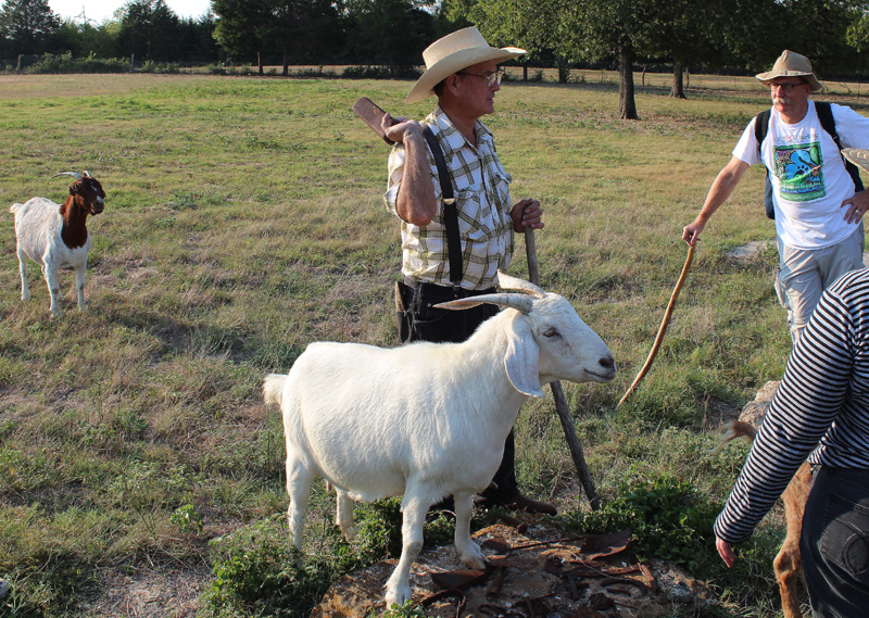
The equinox was a great day to bring together a group of people from all walks of life who are interested in the folks, flora and fauna that make the spring complex in Pleasant Grove. It was a great walk through of local history as told by Mr Pemberton seen above. The photo above was taken at Case Pemberton's cabin site built in the 1880s. The group was just about the right size for such an outing. A great bunch of people I have conversed with via email over the last couple years and I was glad some of us could finally meet face to face. Some were members of the Dallas Historical Society and a member of the Sons of the Texas Revolution. A couple have even struck out on their own and done some of the Devon Anderson, Joppa and McCommas Bluff hikes mentioned here.
The last week of September marks the 169th anniversary of the signing of the Bird's Fort Treaty which brought Sam Houston to North Texas. Signed on September 29, 1843.
It was also a privilege to have local historian MC Toyer join the party. He is the definitive authority on Dallas history, cabins and pioneer genealogy in this part of Texas.
Mr Toyer, seen here standing at White Rock Spring gave a great talk about the background of the spring site, White Rock Creek and Pleasant Grove. So much history happened here on this spot that during our visit we did not get around to discussing the Native Americans who camped here until our return hike from White Rock Creek.
MC Toyer started his talk about the Indian campaigns and expeditions through this area in the 1830s and early 1840s led by General Edward Tarrant and Captain James Bourland. As a result, Bird's Fort was built in present day Euless. From the fort, many veterans of these Indian campaigns who had seen the land, decided to settle the Dallas area using their 640 acre land grants appointed to them as war veterans. Land rich and cash poor, the Republic of Texas paid veterans for their service with land. The scrip was often called Toby Scrip, for Thomas Toby of the Toby and Brother Company of New Orleans, the chief scrip agent. During the republic era, 1,329,200 acres of public land was sold or used directly to retire debt.
Bill Pemberton and MC Toyer at the spring
The Beeman family from Illinois were the first to settle this area permanently. John Neely Bryan and others came and went, in and out of the Dallas scene to follow their fortunes in the California gold fields or real estate speculation elsewhere. The Beeman family stayed. Together as a family they owned large blocks of Dallas land holdings including much of what we now call the Great Trinity Forest.
Big Spring as the Beeman's called it, was on the Big Spring Tract of the Beeman holdings. 320 acres in size this particular tract had two similar tracts nearby called the Prairie Tract and the Cedar Brake Tract. Each tract served a different purpose. One provided great grazing land and farming use. The Cedar Brake Tract provided a source of lumber which was scarce prior to the building of the railroads.
180 acres of the Big Spring tract was inherited by Margaret Beeman, wife of John Neely Bryan in 1856. The Bryan family lived here at the springs from 1867 to 1880. MC Toyer brought along an interesting photo that he believes to be Margaret Beeman standing in front of her home at the spring site shortly after the Civil War. Mr Toyer brought the photo along to see if he could orient the old photo to the contemporary scene. The background did appear quite similar to the present day. Some gravel mining in the area has changed the slope of the terrace over the years so the area where the Beeman cabin was once believed to have stood looks similar but not exact. It would be fun to pursue this further. At the site, since a well was not used at the time, we thought back to how far someone would be willing to walk every morning for a bucket of water.
Big Spring as it looks today
Enter the Pembertons
Corn King Hand Sheller
In 1880 Case Pemberton bought the Big Spring property from Margaret Beeman for $1000 payable in two installments, $400 in January 1882 and $600 payable in January 1883. Case Pemberton ran a dairy operation on his property until his untimely death in the early part of the 20th century. Case Pemberton like many dairymen would deliver milk to town in the morning. Rather than return with an empty wagon, he would fill it with ice, food and other items, then sell them in the afternoons at a small store located at the corner of Lake June and Pemberton Hill. His death came as a result of an armed robbery at his store. After his death, his property, known as Bryan Springs was divided up among his heirs. Mr and Mrs Pemberton live on one such portion of a parcel today.
Case Pemberton cabin site, Olympia the Goat foreground
It does not take much to get Mr Pemberton excited about showing off Case Pemberton's farming equipment. One twinkle in his eye is all it takes to pull out his prized Corn King Hand Sheller. I found an old ad for one dating back to the late 1800s. I believe Mr Pembertons sheller is older than the advertisement.
Billy Ray with a copy of the Texas Declaration of Independence brought by Mr Gibson
Looks like the guy in the ad bent over too far and shucked off the bottom half of his tie! You could spend all day just looking at this old farm equipment, things that were probably hauled in overland by wagon rather than rail.
Really easy to get sidetracked at the garage. Which is a good thing. One interesting heirloom after another comes out of it. A piece of cast iron, some old horseshoes, some blacksmithing apparatus. Each has a story to tell. I always try and make a little time to look at one or two of these old things on a visit. That little bit of time often turns into an hour.
Beyond The Spring And Down Into The Back Forty
The Beeman Walnut Tree
Passing from the high terraced North Texas prairie to the river bottoms is marked by the famous Beeman Walnut Tree. Near the base about 18 inches up is a railroad spike driven into the tree in the year 1908 marking the high watermark of Dallas most historic flood. From this spike, still up on the terrace, one can only imagine the mile and a half wide flood ravaged river that stretched from this point clear to the freedmen's town of Joppa to the west.
It's here, down the slope and into the bottoms where the sounds of the city are completely gone. A dead silence where you can hear an acorn drop 100 feet away.
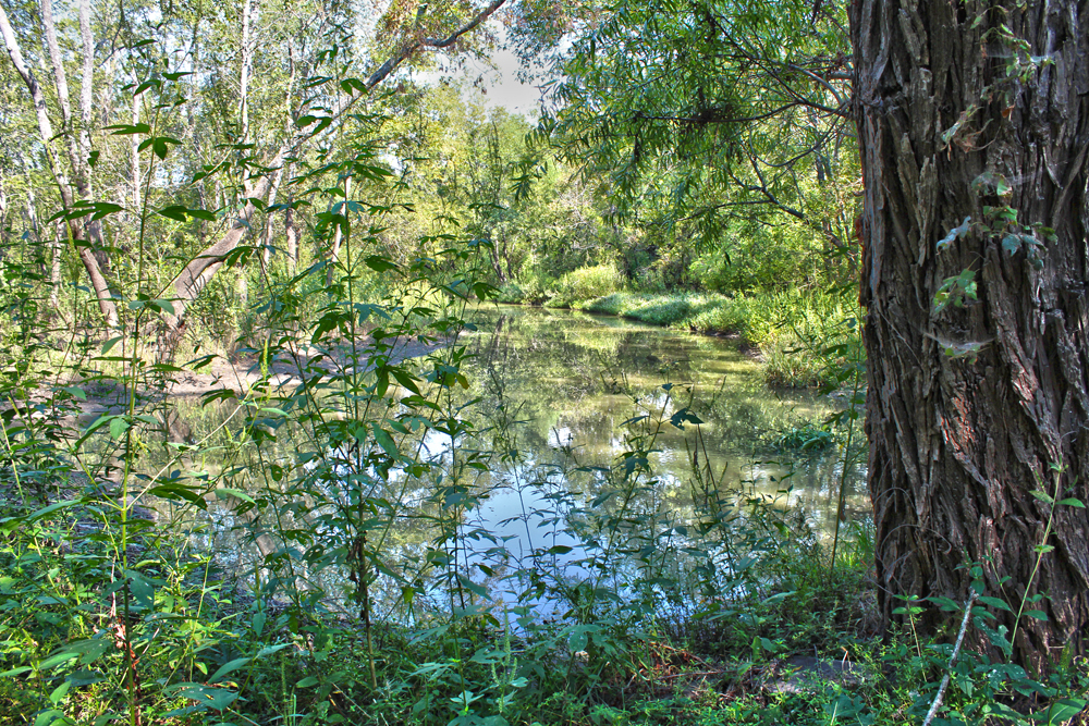
Bryan's Slough and Oak Creek
Down here distant bird calls can be heard a 1/4 mile away and an approaching breeze can be heard before it is felt.
Standing on an active beaver dam looking upstream from Bryan's Slough/Oak Creek
Billy Ray Pemberton and visitors on his old bridle path
Mr Pemberton has maintained the old family bridle path down to White Rock Creek for many years. It follows a series of old fence lines and water features before ending up at the banks of White Rock Creek.
Down here in this remote area the animal prints far outnumber those of people.
The hike here is an easy one from the spring to White Rock Creek. Seen in the picture at right with Downtown Dallas in the background, a companion route could be easily made from the existing Rochester Park / William Blair trails. White Rock Creek has a man made boulder crossing currently in place along the right of way here that makes for an easy dry hop-skip-jump across.
End of the trail along the steep banks of White Rock Creek
Below is a short clip of the White Rock Creek crossing looking upstream. Rochester Park is on the left, Billy Ray's trail would be to the right.
The 2012 Bond Package
I noticed that one part of the 2012 Bond Package up for vote in the coming November 2012 election is a proposal to build a 100 foot deep, 30 foot diameter storm drainage pipe which would drain much of East Dallas and Uptown storm water into White Rock Creek. The video below notes the outlet for the stormwater as the White Rock Creek Outfall.
I cannot find really anything about it online other than this recently posted Youtube video. It gives one pause about what lies in store for Lower White Rock Creek, the Great Trinity Forest and the historic places we visited in this post. It sounds like the floodwaters that originally would have entered the Trinity in the Mill Creek, Turtle Creek and Peak Creek drainages from Uptown through the Arts District, M-Streets, Baylor Hospital and Fair Park, would reroute through Rochester Park and Pemberton Hill.
I wonder where the outflow would be located. Scyene, Second and Bruton all have low bridges that are somewhat prone to flooding during heavy rains. Seems more likely that if an outflow location were selected it would be further south near US 175 or in Rochester Park.
Seems like an ambitious project to relieve certain areas of town from flood waters like Baylor Hospital's emergency room. The cost will manifest itself where all this extra water ends up.
A Special Thanks
A special thanks to the Pemberton family for hosting this event. Their knowledge is something you cannot find in books, online or through a television. It has to be seen and witnessed for your own eyes to appreciate. SYOTT- See You On The Trail
Sharrows are what cyclists call them. Shared Lane Markers, Cycling Chevrons, Yield To Cyclist Markers, they go by many names. A symbol that resembles a bicycle under a roof, stenciled into the road. If you work in Downtown Dallas or frequent Deep Ellum you might have seen them spring up overnight on Main Street, Lamar or even MLK Blvd south of the Fairgrounds.
Bike shared lane marker in front of The Curtain Club Main and Crowdus, Deep Ellum
Sharrow stenciled into the pavement Main @ Exposition Deep Ellum
Dallas has an ever growing infrastructure of dedicated bike paths spread around the city but they all exist in fractured states separated by miles of roads in between. One way to band-aid these trails together is a connect the dots approach using painted icons on the pavement. In theory the stencils generate awareness for cyclists using the roadway. Some critics argue that riding in the road is already a right-of-way right for cyclists in Texas and that the stencils are not needed.
I like them. They mark a somewhat cryptic path from the Katy Trail near the American Airlines Center to the Santa Fe Trail near Fair Park. The roads near Fair Park all twist themselves into a knot and finding the Santa Fe Trail coming from Downtown can often be a challenge. The stenciled pavement helps.
Ludwig Rudine's bicycle and motorcycle shop circa 1913 at 2613 1/2 Elm Street
Riding these streets is nothing new. If anything its a throwback to over 100 years ago. One of the earliest bicycle shops in Southwestern United States and one of the first in Texas was Ludwig Rudine's Rudine and Company bike shop at 2613 1/2 Elm Street in Deep Ellum. Ludwig was a horseless carriage mechanic by trade and transitioned into bicycles then motorcycle service. At the time, bicycles were a popular means of travel in Dallas. Bicycles outnumbered passenger vehicles for a brief period on the streets of Dallas in the early part of the last century before vehicles became more common. As the time, the city of Dallas barely even reached the Fairgrounds, Cedar Springs or even Lemmon Avenue. A bicycle was an easy and quick form of transportation. As the city grew, trolleys and then vehicles took over.
So, what's old is new again........
The plans are to build out stenciled marked streets in connecting loops through Downtown and out Main Street to Deep Ellum/Fairgrounds, another out Lamar Street. Looking around, so far the stenciling exists in the following places:
-Main Street from Lamar all the way through Deep Ellum to the southern terminus of the Santa Fe Trail at Hill Avenue. Getting to the Fairgrounds this way is still somewhat of a jump requiring a ride down Haskell, which is one way. A better route is to ride down to Exposition and Main, ride Exposition to Fair Park.
Cyclists on Main at Pearl, Downtown Dallas
Santa Fe Trail @ Henderson
The goal here is to connect the Katy Trail with the Santa Fe Trail. Doing so would balance two trail systems that have loose ends hanging off to the south. Both are great multi-use paths that if joined together would form a spine of future bike paths.
Known as the SoPa, the Southern Pacific Trail below White Rock Lake
The north end of the Santa Fe Trail terminates at a bridge over Winsted where it merges with the White Rock Lake Trail known as the SoPa, the Southern Pacific Trail. Like the Santa Fe and Katy Trails, this paved path was built in 2000 over an existing rail bed that once ran from Tenison Golf Course to Presbyterian Hospital. Given the 911 Marker Code "SPT" it will retain a different name than the newly created Union Pacific Trail currently under construction from Mockingbird to Northwest Highway.
Union Pacific Trail looking south towards Mockingbird
This newly minted trail still under construction will meet with the Katy Trail Phase IV near the Ridgewood Recreation Center, then continue to the north up through Vickery Meadow. To the south it will tie into White Rock Lake near the Fisher Road Parking Lot.
Union Pacific Trail looking north from Trammel
-Katy Trail down Lamar to the Convention Center is another marked route. This is another decent route that opens up quite a bit once you pass the Convention Center. Headed out this way it's only a five minute bike ride or less to the Santa Fe Trestle Trail. That route, which is unmarked would be Lamar to Cornith, south on Corinth to Riverfront(Industrial Blvd). Hang a left at the big plastic Longhorn.
Shared lane marker at Lamar and Young looking south to the Convention Center
-Martin Luther King Blvd south of the Fairgrounds is the first shared lane street in Dallas. The stencils were placed in April and May from the MLK entrance of the State Fair down to US 175.
Shared lane marking MLK and Robert B Cullum
I thought if there were ever a street that would see the most oil, bus tracks and road grime on it capable of removing stencils, MLK would be the road to do it. In the four or five months that the stencils have been in place they all still look brand new. MLK has a funky lane layout, almost a 60/40 percent lane separation which puts the driver side wheel directly over the stencil. So far, so good.
Heading out the south entrance of the State Fairgrounds the bike stenciling ends at US 175, a few blocks short of Lamar and the MLK/Forest Avenue/Cedar Crest Bridge. I'm not sure why the stenciling ends here but I think it should be extended to the approach of the bridge. The MLK/Forest Avenue/Cedar Crest Bridge has a great sidewalk across it and is the route I always lead bicycle groups across when visiting the Great Trinity Forest and the Standing Wave project.
Shared lane marker at MLK and US 175
I'm not a fan of riding down MLK Blvd. One of the few vibrant streets in South Dallas, the roads and parking lots are usually crowded with cars. I prefer Grand Avenue or Pennsylvania as better alternate routes headed out of the Fairgrounds.
The new Lamar Levee Construction Begins
One new construction project that might make the Great Trinity Forest accessible from the State Fairgrounds area is the Lamar Street Levee Project. I have asked a few people if the final project will allow for recreation activities like hiking, cycling and horseback riding. I got a yes, a maybe and a hold your horses for answers.
Hard to see the signs that construction has started. Tucked in between the Tiger-Tiger Boozarama Liquor Store and the Chicken Shack is a new sign noting the construction entrance.
Lamar Street Levee Map
The Lamar Levee shown above will tie into the current Rochester Park Levee near Bexar Street and then run up the south side of the train tracks to the DART rail bridge near downtown. I have not seen much construction yet other than a fenced off staging area behind Tiger-Tiger on South Lamar and the test drilling site pictured below.
The drilling site sits east of the Highway 310 Bridge and west of the train trestle in Rochester Park. This sits just west of the historic old Miller's Ferry crossing. The new road here cut into the woods just above the riverbank is not long just a couple hundred yards and serves as a test site for soils underlying the future levee site.
It has always been a problem getting around the industrial areas and metal recyclers on Lamar. If the levee offered a workaround the circus there, it would really open up Rochester Park/Blair Park to more people seeking recreation.
In recent decades it has become customary, and right I guess, and easy
enough with hindsight, to damn the ancestral frame of mind that ravaged
the world so fully and so soon. What I myself seem to damn mainly
though, is just not having seen it. Without any virtuous hindsight I
would likely have helped in the ravaging as did even most of those who
loved it best. But God! To have viewed it entire, the soul and guts of
what we had and gone forever now, except in books and such poignant
remnants as small swift birds that journey to and from the distant
Argentine, and call at night in the sky. John Graves Self-Portrait, With Birds; Some Semi-Ornithological Recollections
Talk of birds in Texas during the first weekend of September usually involves opening day of dove season. A quiet time of year when the dog days of summer are fairly scant for seeing wildlife. The birds of the Great Plains, the Mourning Dove, begin their migration from Nebraska and Kansas into North Texas offering hunters a chance to harvest birds in the fallow corn and sunflower fields that dot the outskirts of the metroplex.
Roseate Spoonbills and Wood Storks at Little Lemmon Lake, Labor Day Weekend 2012
It was with much surprise over Labor Day Weekend to see the scene above. Over one hundred rare Wood Storks feeding at Little Lemmon Lake. It has been my past experience that the birds move in like a flying circus in July for a couple weeks then leave. Birds who are easier to find on the rivers of South America than Texas. The Orinoco. The Amazon. The Tocantins. Birds of Brazil, Ecuador, Argentina. Why these birds end up 100 yards from Loop 12 in Dallas is beyond me.
The recurring recipe for attracting these wading birds seems to be shallow drying ponds and lakes that are knee deep on the bird. Find water that deep full of fish and it draws in birds like a magnet. Unique environments to attract birds like this simply do not exist in DFW to any degree. The Corps of Engineers Wetland Project to the north is much too deep and the same with many of the old gravel quarry ponds that dot southeast Dallas County.
Unlike many of the photos I usually take which are hip deep in mud or weeds the photos at Little Lemmon Lake were all taken standing on concrete. Some even standing on top of park benches that dot the lake. Getting to Little Lemmon Lake is a breeze. Located just south of Loop 12, dedicated parking lots exist for both the Loop 12 Boat Ramp and Little Lemmon Lake. The concrete path stretches from Little Lemmon Lake, south to Simpson Stuart Road. The best address I have for Little Lemmon Lake is the 4600 Block of Great Trinity Forest Way(Loop 12). Google Map link 4620 Great Trinity Forest Way.
Great Trinity Forest Trail Map
Originally purchased from Jack Apperson in the 1990s, Little Lemmon Lake has served as small recreational lake for decades in private hands. Leased off and on over the years by a local man named Bad Leg Fred, many locals still call the lake by his name. Bad Leg Fred Lake. Many spots named on maps, Google Earth and USGS surveys go by completely different names by the locals who call it home. Bear Hollar, The Post, The Crossing, Juju Heights, Pig Park Rodeo, Possum Bend. I always get a kick out of talking to the old timers on this side of the river because their oral history, what they witness with their own eyes is often completely different than what is printed in books, reports or the newspaper. Were it not for the wildlife, I think the people down here would be just as fascinating to know.
American Avocet, Tri-colored Heron and Snowy Egret
Later in the year than previous spottings, new bird species have shown up to share the lake. The overlap of migrations creates an interesting mix of birds from South America, birds from the US Interior/Pacific West Coast and birds migrating down from Canada.
One of the more interesting is the American Avocet. A chicken sized bird with a straw shaped beak that curves upwards. Black/White/Grey in appearance these birds live mostly in the Western United States and out on the Pacific Coast. In late summer, they often disperse further east and are listed as casual vagrants in North Texas.
Flock of American Avocets and a Great White Egret at Little Lemmon Lake.
The River Otter Family
North American River Otter and American Avocet at Little Lemmon Lake September 1st, 2012
Little Lemmon Lake still flies under the radar as literally one of the only places to see a North American River Otter Lutra canadensis in North Texas and possibly the only public spot in Dallas to see one on a routine basis. The river otters diet consists mainly of rough fish here in Texas, the kind of fish that abounds in the Trinity. Much of their lives and habits are simply not understood since they are few in number and hard to see here in Texas.
The birds actually follow the river otters around in the lake. Stirring up debris from the bottom of the shallow lake, the Avocet above follows at a comfortable distance to sift through the churned up silt.
Other birds take initiative on their own and in an interesting feat, a White Ibis killed a carp on its own then pecked pieces off one by one. The video clip is below.
I thought White Ibis preferred smaller minnow sized fish, crawfish and bugs. Pretty cool to see an Ibis take on a fish that probably outweighed the bird.
I lost count at over 100 Wood Storks in Little Lemmon Lake. The Wood Storks are easy to identify by their brownish heads and necks that almost resemble tree bark. The dozen or more Spoonbills and the countless herons, egrets, ibis and wading shorebirds must put the headcount there at over 500. As is customary for Wood Storks, they feed in organized groups, moving in unison from one end of the lake to the other driving prey in front of them.
Blue Winged Teal Ducks
Blue Winged Teal Ducks at Little Lemmon Lake
The first ducks to migrate south in the fall, the Blue Winged Teal often signals that fall is not far behind in North Texas. Smaller than other species of ducks, these birds are often mistaken for juveniles of other species. One of three teal duck species they are only about a foot long and weigh about a pound. The last two years there have been resident fall flocks of these in the furthermost southern wetland cell north of Loop 12 near the old Sleepy Hollow Country Club Parking lot. That particular pond is an older more mature pond leftover from the days when that area was a golf course. I would guess that the food sources are more plentiful there than the newer Wetland Cells closer to the river.
Canadian Geese
Canadian Geese
Not in the regular flyway of Canadian Geese who take a more easterly route, the group of four Canadian Geese seen above were in Little Lemmon Lake as I arrived and left shortly thereafter. Last winter two Canadian Geese were in the Wetland Cells north of Loop 12.
Wetland Cells looking downriver from the Highway 310 Bridge, September 1st
Lemmon Lake's Last Waterhole
Lemmon Lake on Labor Day Weekend
Gar carcass at Lemmon Lake
Lemmon Lake's last waterhole went dry sometime in August. Before that happened I stuck a camcorder in the waterhole to record what transpired during the night. The water, the trapped fish and the newly created mudflats are a big draw for the feral pigs, coyotes and bobcats that live down here. Below is some of the footage condensed down into 5 minutes. Looking through the footage, the coyotes howled all night long, spaced about 30 minutes apart. Almost the perfect length of time to insure zero sleep if you were camping down there. I have been down in this area when it was still light outside, a full hour before sunset and the coyotes will howl, often from places you walked just minutes before.
Below is the condensed video of that with notes of the times that certain things took place. At the time of the filming, the waterhole was teeming with gar, carp and even some baitfish.
A dry Lemmon Lake allows easy travel to some usually inaccessible spots on the eastern edge of the lake. Here the river runs down the east side of the dam and the erosion caused by periodic flooding has nearly undermined it in some places. The width of a sidewalk in some places I would guess it will not survive the next few flooding events.
East side of Lemmon Lake
Lemmon Lake is bisected by a spit of land running down the length of the lake. During normal lake conditions, the west side of the lake is open water while the east side remains a dense and deep swamp. Seen in the photo above, this is literally the deepest darkest part of the Great Trinity Forest where few people ever venture. The shorter plants here are handlebar high on a mountain bike, 3 1/2 feet. The grass beyond it is 8 feet or higher and a literal wall. To the right beyond the trees is the Trinity River. Currently the dry lakebed is easy to ride across. Without more rain soon, the lakebed will eventually crack making travel across it more difficult.
It's impossible to give a size of scale here looking out over this high sea of grass. Maybe one hundred acres or more of just raw wild swamp. So large that the trees seen in the foreground right are the same size as the trees on the distant horizon.
aNgRy Skunk at Lemmon Lake
Getting back to this area is not difficult. It just takes a
tremendous leap of faith that something does not jump up at you from the
weeds. Like skunks. The skunk at left and the others that wander around the lake bed must be the angriest little animals in all of Dallas. Like a group of rabid meth heads that boldly wander across the lake foraging for aquatic things left high and dry. Nasty little critters. They will jump at you, stomp their feet, turn around then aim their scent glands right at you while standing on their front paws. I was far enough away to not warrant spraying. I'd hate to come across one in the high weeds for sure.
The trail through the knee high weeds is easy to follow at the moment. Meandering along the north side of the dam, the trail is probably used mostly by pigs and coyotes. At dawn or dusk the chance to encounter one of these animals along this trail is probably high.
The photo at right is looking from southwest to northeast along the dam. The furthest trees are roughly 1500 feet way and all roughly the same size. Even seeing it for yourself, the distances are hard to grasp since there is no frame of reference.
The one exception to the trees down here is the tallest cottonwood at the lake. The tallest tree in Dallas, according to the DFW Tree Database. At 120 feet in height, it towers over other trees in the area. It sits at the southeast corner of Lemmon Lake about 100 feet from the Trinity River. It lacks the crown spread and mass to be the largest tree in Dallas but has the height.
The tree is so tall that when you get to the base of it, you cannot even hope of seeing the top.
Spreadsheet noting the height of the cottonwood tree at this location
Trunk of the tallest tree in Dallas
The lake went dry here last summer and refilled during the heavy rains of last winter. Hopefully in the future this could be a great place to view wildlife year round. I was told it was originally on the short list of sites for the Trinity River Audubon Center. Wildlife abounds here with plants and animals not found within one hundred miles.
The headwinds facing this place are not so much to do with the land itself but the nefarious activities of some people who come down here. I have been told recently that hunting is not allowed down here, by anyone, for any circumstances. I keep getting emails from folks who have come across people hunting with dogs, a dead hog in a truck, people with firearms or as in the case of the photo to the right, a large tree stand. Pretty bold to do that.
Even taking the photos at Little Lemmon Lake on September 1st, a large amount of gunfire erupted from the west side of the lake on private property currently used as a salvage yard on Carbondale. Up to 100 rounds were fired in my general direction with a couple zipping over my head, many hitting the lake full of birds some of which are listed as Endangered Species. All the birds took off, none looked injured. Despite calling 911 to report the gunfire, no one called back(as they promised to) or came to investigate. Third time I have been shot at down there. Third time I called the police. Third time no one showed. The police down here that I meet in person keep telling me to report things like this because it will get more patrols in the area. Calling things like this in seems to not do much good, it appears. Be careful!


 It was also a privilege to have local historian MC Toyer join the party. He is the definitive authority on Dallas history, cabins and pioneer genealogy in this part of Texas.
 180 acres of the Big Spring tract was inherited by Margaret Beeman, wife of John Neely Bryan in 1856. The Bryan family lived here at the springs from 1867 to 1880. MC Toyer brought along an interesting photo that he believes to be Margaret Beeman standing in front of her home at the spring site shortly after the Civil War. Mr Toyer brought the photo along to see if he could orient the old photo to the contemporary scene. The background did appear quite similar to the present day. Some gravel mining in the area has changed the slope of the terrace over the years so the area where the Beeman cabin was once believed to have stood looks similar but not exact. It would be fun to pursue this further. At the site, since a well was not used at the time, we thought back to how far someone would be willing to walk every morning for a bucket of water.