This practical guide takes readers to the best trails found in the Great Trinity Forest, all within easy reach of Downtown Dallas. Destinations include less traveled, low-traffic areas for hiking, mountain biking and horseback riding in the City of Dallas. Joppa Preserve, McCommas Bluff Preserve, Trinity River Wetlands, Texas Horse Park, Dallas Trinity Paddling Trail, Lower White Rock Creek, Sycamore Dixon, Texas Buckeye Trail, Dallas Whitewater Wave, Levee Trails, Rochester Park and more.
Polished like a ripe apple of autumn the Piedmont Ridge, Oak Creek and Devon Anderson Red Oaks ooze a palette of red, yellow and orange unique to this part of Dallas. The frost red thickets perched fifty to one hundred feet above the Great Trinity Forest offers one of the better fall foliage viewing areas inside the city limits. On the clearest of clear days from these heights one can gaze in the far western distance Cedar Ridge which shares the same White Rock Escarpment topography, flora and geology as this part of East Dallas. Like most of the Great Trinity Forest the bluffs and promontory overlooks here have a deep history, spartan hard to follow trails and rewarding scenery for those willing to get off the beaten path.
Piedmont Ridge Trail Overlook, view towards Oak Cliff Bank Tower on horizon
The bottomlands beyond the escarpments lie relatively unwalked and unexplored for years at a time. The towering second growth trees sprinkled with old growth is one of the greatest places to explore in the city. A place that lacks roads, trails and the construction work of 21st century man. Beavers do the construction here ten feet of dam at a time. Here they are slowly transforming the once channelized and de-watered White Rock Creek for Grover Keeton Golf Course back into a permanent marsh. A quiet and near impossible place for humans to venture. The fingers of the Trinity River Project do not reach down here. Nor will they. Wet nine or more months out of the year this backwoods area will always remain as it looks today. Those with a degree of rare country sophistication would appreciate a place like this.
Bruton Bottoms in the Great Trinity Forest
Those looking for a quick hike covering lots of ground need to look elsewhere. Traveling here is a thinking man's game where arduous bramble thickets should be viewed as a place to slow your pace and drink in the scenery. It's a pleasure to walk down here looking for the few and far between bois d'arc fencelines left by post cutting pioneers. Duck canvas pants and a thick pair of work gloves will take one far here.
JJ Beeman Trailhead sign
Like much of the Great Trinity Forest this land was settled by the Beeman family. Granted 4th class headright by the Republic of Texas in November of 1842, exactly 170 years ago, James Jackson Beeman's 640 acres were roughly between what is now Scyene and Bruton near present day Jim Miller Road. A trail west of the Scyene Overlook bears his name that if were more frequently maintained would reach the Lawnview DART Station.
JJ Beeman is an important figure in North Texas history. On President Sam Houston's visit to White Rock Spring in the summer of 1843 it was JJ Beeman who guided Sam Houston's Treaty Party from their overnight camp at Big Spring up White Rock Creek to John Neely Bryan's cabin in what is now Downtown Dallas.
Sam Beeman, Mrs John Neely Bryan Sr, John N Bryan Jr
Many paths crossed on that Treaty Party trip. Whether the long lasting friendships were forged before this meeting I do not know. In the proceeding years many of these men would meet together again fighting under the stars of three different national flags. The Texas Lone Star, The 28 Star American Flag and the 7 star flag of the Confederacy. John H Reagan a member of that treaty party later became US congressman, Confederate Secretary of the Treasury and post-reconstruction US Senator. Reagan and Beeman had a mutual friend in Nathaniel Burford . After Beeman returned from the California gold fields as a '49er, he land swapped his White Rock Creek holdings for land in Parker County. Beeman built a fortified stockade out there called Beeman's Fort. Under a large oak on Beeman's property, Nathaniel Burford held the first district court session for Parker County. The tree, known as the District Court Oak still stands today.
He must have been a restless sort, holding the job titles now trademarked by every professional sports team in DFW. Texas Ranger, Dallas Cowboy, Maverick, Rough Rider. His constant travels across Texas and the West make him all but a minor blip in most Dallas histories but he deserves more credit for what he did here in Dallas.
Pioneers of the Trinity
Thunderhead over Beeman Cemetery
The old worn faces in the photo above represent many of the people I have mentioned in previous posts. The Beemans, Cochrans, Bryans, Hunnicutts, Fishers and others gathered at a pioneer reunion at Oak Lawn at the turn of the last century. Most of those pictured were born, lived and buried in what we now call the Great Trinity Forest. Mrs Margaret Beeman Bryan seen bottom row, second from right was married to Dallas founder John Neely Bryan and lived for many years at White Rock Spring now located down pasture from the Pemberton Farm. Her relatives, cousins and neighbors fill the photo.
Many of those folks now rub shoulders at the Beeman Cemetery just like they did in that old photo. I would hazard a guess that two-thirds of those in the photo now lie in repose there. Sitting on a hill, a stones throw from the upper limits of White Rock Creek's floodplain the old cemetery was chosen as a garden spot of a cemetery by John Beeman in the 1840s.
The Trails
The archaic and sun damaged topographical map I once pointed people towards at the Piedmont Ridge Trailhead kiosk no longer exists. Removed or taken I do not know where it walked off to. The trails here really don't lend themselves to a map since they become difficult to follow in some areas. At best all I can offer is the GPS data map overlay which gives somewhat vague reference points to the Lawnview DART Station(green), Renda/Laceywood Trailhead(top yellow), Grover Keeton(middle) and Devon Anderson(bottom). The ideal parking location is inside the Grover Keeton golf course lot, west of the DART tracks. This allows for an out-and-back hike from the safest parking area.
The Lawnview DART route now requires a heavy bushwhack and not recommended at this time.
Hutchins quadrangle annotated with Scyene, Laceywood and Piedmont Overlooks. Map credit Tim Dalbey
Click to enlarge map credit Tim Dalbey
I have included the USGS quad for Hutchins which gives topo beta for the trail and overlooks in the area. Access to the west side of the DART Green Line ROW can be made on foot or bicycle from a DART gravel road near Glover Pass, Grover Keeton Golf Course or a bridge underpass just south of Bruton Road. A parallel set of train tracks sits slightly off grade from the DART light rail. This seldom used rail line is rumored to serve the Dal-Tile plant on I-30 from time to time. It sits outside the DART fences and given the amount of excess ballast used in maintenance almost lends itself to a halfway rideable route on a mountain bike.
The marsh notations south of Bruton are "Bruton Bottoms". I would only attempt an excursion down there with a group, good GPS, a fresh roll of flagging tape and a good head on your shoulders.
Scyene Overlook
Scyene Overlook
The best known overlook in this trail system is Scyene. Roughly one hundred yards south of the road bearing the same name the overlook gives one a commanding view of the Great Trinity Forest to the south. Most days the VA Hospital, Wilmer/Hutchins water towers and the aerial towers on Cedar Hill are visible with the naked eye.
Scyene Overlook
This overlook is named for an old frontier town two miles east of the overlook named Scyene. The town center was at the present day intersection of Scyene and St Augustine . The name "Scyene" is a play on the ancient Egyptian town named Syene an old frontier outpost on the east bank of the Nile. Around 500 BC, the same time the Book of Ezekiel references the ancient Egyptian town of Syene (Aswan), some ancient Native American left behind a Gary dart point(arrowhead) here on the bluff. Stories as old as the Old Testament were probably told here along what was an old Bison Trace which later became Scyene Road.
The millennium old natural bison path and hard bottomed ford of White Rock Creek made this a preferred ox pulled wagon route into Dallas prior to the railroads. The long haul interstate truckers of their time.
In the last month, historian MC Toyer and archeologist Tim Dalbey have been out on a field trip or two in this area checking into a possible gravesite of outlaw Belle Starr's family and an old post Civil War era cabin in the Parkdale neighborhood(a few blocks from the overlook) that has a contemporary veneer on the exterior but logs/planks underneath. Owned by a well known local artist it might be one of the oldest structures in Dallas still on the original foundation. Or not.
Scyene Overlook map. Credit Tim Dalbey
The pounded down rocky rat holes left behind by years of off road vehicle use at Scyene Overlook have made deciphering the old ATV trails from new hiking trails quite difficult. Looking at the eroded gullies one can imagine these were used in hill climbing contests for motorized dirt bikes and off road vehicles at one time. Gazing the topographic map above with trail overlay one finds it difficult to make sense of what route to take. The Groundwork Dallas trail is unmarked, unblazed and ripe with deadfall making for a puzzle of a walk. Follow your own line here and you'll be fine.
Orchids- There are five species of Hexalectrus orchids that are found in Texas out of seven species worldwide. Out of these five, four occur in Dallas County. In the most recent orchid census, Scyene Overlook had the third highest number of orchids in the county, all were the H. spicata spicata species. The orchids here are quite rare and rely on a specialized relationship with soil fungus to acquire their carbon rather than sunlight. These species cannot grow under artificial conditions or be propagated by humans.
At one time, the city wanted to pave Scyene Overlook's trail and place an observation tower on top of it so that visitors could view Downtown from a distance. One of the rubs is that visitors cannot see Downtown from this vantage point. To do that one need only cross the Renda Meadow to Laceywood Overlook.
Laceywood Overlook- The overlooked overlook
Tree covered Laceywood Bluff
A mere footnote to Scyene Overlook, the Laceywood Bluff is everything Scyene Overlook is not. Sitting at the same elevation as Scyene but oriented north to south and facing west, Laceywood Bluff offers a great view of Downtown Dallas few ever see from the east. The tawny colored facade of fall oaks hide the brilliant white outcropping beneath.
Cottonwoods along unnamed brook through the Renda meadow
A five acre, tall grass meadow stands between Scyene and Laceywood with a small intermittent dry wash peppered with cottonwoods and willows. Reaching the meadow is best done from Gateway Park on Jim Miller as no formal parking exists on Renda or Laceywood. Both of these trails would be great for dog hiking.
View of Downtown Dallas from Laceywood Bluff
Laceywood sits fifteen feet higher than Scyene and the afforded extra elevation barely clears the tops of the highest pecan trees in the creek bottom below. That lends itself to a great set of pocket views featuring Downtown Dallas as a reward from the top. Two or three very informal foot trails lead to the top. One starting at the Renda Meadow which is rather steep and the other a longer and more pedestrian route from the baseball fields in Gateway Park.
Sumac on Laceywood Bluff
Piedmont Overlook
The Piedmont Overlook sits east of Jim Miller and can be best accessed from Gateway Park on Jim Miller. Hop across Oak Creek and begin the climb from the south. The west facing slope resembles scree and far too loose to hike up. Kicking rocks loose in this area would end up on Jim Miller vehicle traffic below.
The elevation of this bluff is the same height as the Laceywood Bluff and therefore is blocked from a view of Downtown Dallas. No formal trail exists that I know of. This is an orphaned section of bluffs that extend along the east side of Jim Miller from Scyene to Bruton. The road cut for Jim Miller bisected the rock feature here and left the eastern sections cutoff from the rest. I have wandered around some south of Gateway Park on the east side of Jim Miller and have not found much of note.
Many of the larger trees along Oak Creek in a residential neighborhood that back up to Gateway Park pre-date pioneer settlement of Dallas County. A recent postmorteum was done on a felled oak tree in the 2200 block of Santa Cruz. The Post Oak was dated at 134 years old with a radius of 11.99 inches.
Piedmont Ridge
Piedmont Ridge Overlook
The most well established, easiest to follow and best maintained trail in this area is the Piedmont Ridge Trail that stretches from the Grover Keeton Golf Course entrance road, south to Bruton.
Climbing a short set of switchbacks puts one on a flat plateau of exposed remnant blackland prairie and lends itself to open sky views not afforded at other overlooks. Here you can usually see buzzards wheeling the sky, riding the warm thermals created by an ever present southerly breeze. The sweet smell of juniper on the hottest of days can transport one to the scrub of the Llano Estacado without ever leaving the city limits.
It's a place where the old settlers mule teamed plows found the rocky ground to thin to work and their cattle found too steep to venture. Left to their own devices the old growth red oaks in this section of trail are most likely antique in age living prolonged sheltered lives of bourgeois pride on the limestone.
Devon Anderson
Devon Anderson Park
The cryptic entrance to Devon Anderson's trail near Bruton Road has cut many a hike short through the frustration of not being able to find it. Roughly 50 solid paces east from the DART ROW fence along a Chinese Privet hedgerow, the opening can be tough to find. The trail climbs through matted privet and up short sets of switchbacks to tree canopied sets of ridges and steep gullies.
The Half Mile Overlook
Intertwined behind a couple modular looking cul-de-sac'ed neighborhoods the trail runs north to south from Bruton to Eastcliff. There are two or three vantage points in Devon Anderson where one can see Downtown Dallas. Steep and off camber in most areas the trail does not lean well towards someone on a bike. More pushing than riding eighty percent of the time it's best traversed on foot.
The wooded trail opens up into an open wildflower meadow near the trailhead junction of the overlook trail and Comanche Storytelling Place trail. The Devon Anderson Meadow is set afire from time to time by what are probably neighborhood youth. It burned down at least twice in 2012 that I know of. The coming spring will tell the tale of what ancient fire DNA lives in the seeds in the ground here.
Comanche Storytelling Place
The Comanche Storytelling place serves as a prominent anchor to the southern end of the trails here. Beyond are steep root strewn gullies that lead nowhere. The Storytelling Place is something of a conundrum. The Comanche people named this natural ampitheater as a holy place in the late 1990s after a brief visit to an Indian Marker Tree that once stood in Gateway Park. The Comanche had no written language and used parables told orally to explain their people's history. Parables like those of the seasons, the animals and planets all played a forefront role in Comanche lifestyle. The Storytelling Place combines a few of these elements including the cedar, limestone and elevation required for Comanche holy spot. Here under the fragrant decay of fresh fallen leaves one could imagine a small Comanche band retelling old animal stories before a fall hunt.
Quietly meandering from the heart of a downtown metropolis to the edge of the rural Texas countryside, the Trinity River Paddling Trail offers a unique look at a slice of Dallas few people will ever see. A float through The Great Trinity Forest.
The misinformed myths of the Trinity told by modern yarn weavers serve as more of an impediment to exploration than the physical barriers on the river itself. Seen as a blight by most, few realize that the navigable river mere blocks from their homes affords a simple inexpensive day adventure into some of the most remote and wild places in the state. It does not smell. There is little visible trash. Many of the stretches look like the Brazos, Colorado or Sabine. Snags are few and far between. Bad press and bad rumors have resulted in very little information about this stretch of river being posted online, in print or even by word of mouth.
This was a trip that I have wanted to take for some time. Many of the special places along the river cannot be accessed by land. Locked behind high fences of the industrial plants, behind railroad marshalling yards and impassable swamp. The places I could only view from afar or not at all. Floating the river gets you there. This particular trip follows the course of the Main Stem of the
Trinity River from the Santa Fe Trestle Trail to McCommas Bluff. A ten mile route book ended by the Dallas Standing Wave and the Trinity River Navigation Company Lock and Dam #1.
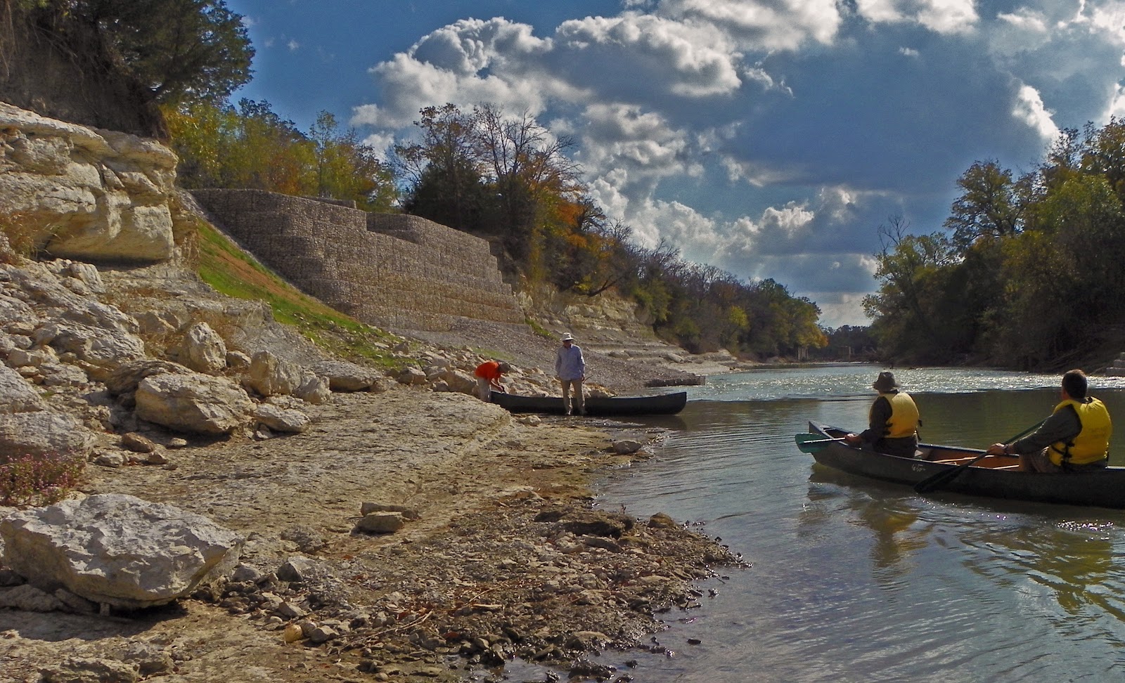
Put in-Santa Fe Trestle Trail at the Trinity River
The real obstacle I had to wait on was the Trinity River Project itself. In order to legally put in canoes on the Trinity River, construction of the Santa Fe Trestle Trail had to be completed and open to the public. That happened in late October 2012. Launching canoes below the Standing Wave was the only real option with the Sylvan Avenue Boat Ramp closed until January of 2014.
Take out- McCommas Bluff Preserve
The idea was to transect the entirety of the Great Trinity Forest by canoe. Explore the mouths of larger creeks, bridges, rapids and obstructions that can only be seen by boat. The Dallas Trinity Paddling Trail is one of 38 Texas Paddling Trails that dot Texas. Half a dozen of which are in the Trinity River basin.
From the outset, the hardest part of the trip appeared to be getting the boats to the river itself. With a locked gate near the DART train station on 8th Street, the portage of carrying canoes down to the water would surely tax even the strongest of arms. Be prepared for the extra time and effort it takes to accomplish this. In addition, a number of news articles have been written about issues concerning the Standing Wave/Dallas Wave . One can easily avoid the soap opera surrounding all that by putting in just downstream.
Joppa Preserve on the Trinity River, November 2012
This trip would not have been possible without Charles Allen, owner of Trinity River Expeditions canoedallas.com based in Oak Cliff. He has thirty years experience guiding trips, the majority of those on the Trinity. While he did not accompany us on our trip, his knowledge of the Trinity is second to none. The shoals and obstructions he knows by memory, he can draw a precise map by hand and is easily the best Waterman in Dallas. If you are looking for a guide on the river here in DFW, he is your guy. Cost for a day on the river is very inexpensive, what many would pay for a trip to a movie or a happy hour bar tab. Charles is one of those special people that make Dallas worth living in.
I wish the city would embrace him as an asset to the Trinity. They need
him.
I'll also add, one last time, just to make it perfectly clear that we followed the letter of the law putting-in at the Santa Fe Trestle Trail. The park is now open to the public and construction is complete.
Once afloat it's easy to break this particular route up into three distinct sections of river.
-The early 20th Century industrial area in the shadow of Downtown Dallas
-The old trees, old ferry crossings and old Indian campsites near Miller's Bend
-The true wilderness of the Great Trinity Forest south of Loop 12
Each section of river has it's own feel. One section takes over where the other left off.
10 mile route with mileage markers highlighted from Santa Fe Trestle Trail to McCommas Bluff
River Beta:
River height at Commerce Street Bridge: 15.2 feet
Flow: .355 kcfs
Length: 10 miles, 4.5 hours on river
Current Conditions :River gauge at Commerce Street Bridge
14-15 feet is a low flow height for the river. The sites we saw and some of the obstructions would not be visible if the water were a foot or two higher. Flow pushed the canoe along at a slow pedestrian 1-1.5mph through most sections.
Standing Wave to I-45 -- A look at the Industrialization of the Trinity River
1911 George Kessler Plan, Union Station seen at middle right
The founding fathers of Dallas always envisioned a grand inland port on the Trinity. Newcomers to Dallas might not know that the current Trinity River Project is not the first or second try at improving the river. It's version 3.0 or 4.0. If you are unfamiliar with the river's more recent past a great documentary exists on the subject.
The ten or so river miles floated from Downtown to the edge of the city limits allows one to see the three or four different attempts to tame the river. The first section is the most developed from the old Santa Fe Bridge to I-45. Running behind some of the old heavy industrial areas of Dallas.
Standing Wave prior to submersion in December 2010
Constructed in 2010, the Trinity River Standing Wave serves as a Whitewater Park near Downtown Dallas. Part of the ambitious 1998 Trinity River Project the twin standing wave submerged dams create a hydraulic wave that can be ridden by specially designed whitewater kayaks. Canoe bypasses were built as part of the design on "river left", seen in the picture on the right side. The steel bridge in place here was built in 1904 and later elevated an additional few feet in the 1930s so that it would sit higher than the Trinity River levees just upstream. Thus making it flood proof.
Mouth of Cedar Creek
32°45'5.08"N, 96°47'17.34"W
Mouth of Cedar Creek, Moore Park
"To the memory of Colonel William G. Cooke and forty other members of the Regular Army, Republic of Texas, who camped in this vicinity in October, 1840 while locating the Central National Highway. The importance of this military road in the history of Dallas will not be forgotten. " Texas State Historical Marker 1936
Just downstream from the Standing Wave is the mouth of Cedar Creek. Most know it as the creek that flows through the Dallas Zoo. Where this creek meets the Trinity River a small fort once stood, built by the Army of The Republic of Texas during the expedition to scout a Military Road from Austin to the Red River. I-35 now follows that route.
Two maps, below, are courtesy of Mike Toyer a noted Dallas historian who accompanied us on the canoe trip. Cedar Creek is labeled "Houghton's Creek" in the maps, named for Captain M. B. Houghton. Both are very rare old maps that give a glimpse into the wilderness that was once Central Dallas. Both maps can be clicked on to enlarge.
Upshur's 1841 Map showing the Rio Trinidad, Cedar Springs and stockade on Cedar Creek, from Joseph Milton Nance's After San Jacinto: The Texas Mexican War 1836-1841
Colonel Cooke's Military Road and Campaign Map 1841
It's interesting to note that these 170 year old maps are still accurate in regards to navigating the Trinity River downstream of Cedar Creek. The creeks and unnamed sluices drawn on these old maps still reach the river today. An ice age bison, bison antiquus, that walked these banks 10-20,000 years ago was discovered here fairly recently testifying to the presence of the untouched stream channel in this area.
Old Forest Avenue Bridge
32°45'3.97"N, 96°47'10.74"W
Old Forest Avenue Swing Bridge
Downstream of Cedar Creek and just upstream of the new Cedar Crest Bridge sit the foundations of the old Forest Avenue Bridge. Designed as a "swing bridge", the circa 1917 structure was built to allow tall barge traffic to pass in the event the Trinity became navigable to large ships. This bridge was replaced with the newer Cedar Crest Bridge. In low water a shoal is just upstream of this feature. Keep river right to avoid.
River bend just past the Cedar Crest Bridge
MKT Trestle
32°45'0.06"N , 96°46'38.94"W
MKT Railroad Trestle over the Trinity River, South Dallas
The old Katy bridge dates supposedly to 1905 and is one of the oldest railroad bridges still in operation over the Trinity River, if not the oldest. Few ever see this bridge. Tucked away behind a few bends in the river it stands a silent citadel to the river beyond. From this point on, save for a few freeway overpasses, the city that surrounds the river is silent. The river and the 4000 acres of trees that surround it soak up noise like a sponge.
Limestone Seeps
32°44'59.04"N, 96°46'36.47"W
Limestone seeps near the MKT Trestle - P&G Plant
Austin Chalk forms the backbone of the north(east for some) bank of the Trinity River from the MKT Katy bridge to the I-45 bridge. The geology here is simple. The Late Cretaceous age Austin Chalk and Taylor Marl were once part of a vast inland sea. This rock, known as the White Rock Escarpment, dips to the southwest at 15-40 feet per mile.
Ice Age gravel over Cretaceous Austin Chalk, Reverse Fault
Over the passage of time, the Trinity has cut into this old rock leaving behind the Trinity Terrace, the Ice Age reddish gravel seen in the photo above. Millions of years separate the ages of the two rock formations. No one knows what happened inbetween. The ice age gravels, are full of fossilized mammals from this era. Mammoths, camels, sloths that once walked here. The weather was a little cooler and wetter than it is today but not by much. Live Oaks, Osage(crabapple) and familiar grasslands were nearly the same as they look today.
Dripstone outcropping on the Trinity River
The porous nature of the loose gravel and the block sedimentary nature of the limestone create dripstone along this section of river. Much like the stalactite, water flowing across the rock has left behind minerals creating this unique rock formation.
The Proctor and Gamble Pumphouse sits some 500 yards south of the Proctor and Gamble Plant on Lamar in South Dallas. Built in 1919, the plant was constructed at the vital crossroads of two major railway lines and in close proximity to the Trinity River. The two story structure here served the purpose of providing cooling water to coal fired boilers behind the plant and also non-potable water use not involved in the production process. By the time this pump was operational, new standards for sanitary disposal of wastewater were law. Pumphouses such as this can only lift water in feet height equal to the atmospheric pressure in water, 34 inches, which translates to 34 feet. Roughly the same height as this structure. This plant was modeled after a sister factory in Cincinnati on the Ohio River.
I-45 Bridge
32°44'16.29"N, 96°45'58.73"W
Negotiating the constricted narrowing channel at the I-45 Bridge (Bill Holston, Scott Hudson pictured)
The I-45 Bridge, built in 1971, was another bridge constructed with the belief that one day high profile barge traffic from the Gulf of Mexico might one day turn Dallas into an inland port. The constricting ballast on either side of the river speeds up the waterflow before entering Miller's Bend.
Fisherman at the Central Wastewater Treatment Plant discharge site
Whatever floats your boat. The fisherman above said the discharge pipe area was a great fishing spot and his favorite on the river.
Miller's Ferry to Loop 12 -- Ancient Fossils, Ancient Indian Villages, Ancient Trees
Simple geography keeps this next section of the Trinity from ever being developed or molested by the hands of modern man.
Prominently standing in the Yale Peabody Museum at the turn of the last century was a specimen of Elephas imperator recovered from an area near Loop 12 and the Trinity River. Seen in the photo(right), displayed at Yale with other fossils from the Pleistiocene era. Many of the other animals featured in the photo are part of the O.C. Marsh collection. The great reserves of Ice Age fossils locked away here in the Trinity River are unknown to contemporary Dallasites. Over a dozen of these large animals were excavated from a small area here. I'm certain many more are still there, victims of an old quicksand flat.
Much of this area sits ignored. Which over the course of time has preserved much of it. Some bends of the river that still carry the names of the old pioneers are concentrated in history. Like Miller's Ferry and the 3000 years of history there. Much of that history never made it into a book, matter of fact it still sits on the bank today. Someday I hope that South Dallas realizes they have a place where the rich history of emancipation and freedom can be shown hands-on. It's one of the more powerful places on the river to experience.
Native Americans
Old cowboy westerns have seeded the idea that the Comancheria, the name given to the nation of Comanche once fearsomely lorded over what is now Dallas County. That might be true. But just for a brief moment of time. The Cotton Bowl might have been standing longer than the Comanche cavalry ran roughshod here. The real story is not the Cherokee either. It's the Caddo.
The Hasani are a populous nation of people, and so extensive that
those who give detailed reports of them do not know where it ends. They
live under an organized government, congregated in their pueblos and
governed by a cacique who is named by the Great Lord, as they call the
one who rules them all -- Bishop Of Guadalajara, 1676
The lost village of the ancients
Thousands of years ago some ancient race of people lived in the woods you
see in the photo above. Their history is unwritten. Here in these woods, in this
very spot a great ancient civilization flourished for centuries. Charcoal analysis from their cooking fires tell us the woods looked the same today as they did when this site was called home for those ancient forefathers of Dallas.
A
civilization that were master hunters. Master craftsmen. Masters
artisans. Master traders. They are a group of people to whom no current
humans alive will claim as descended from. Wichita? Caddo? Proto-Caddo? Maybe some unknown
race of Anasazi that vanished without a trace?
Often, great leaps of theory and conjecture accompany wild stories of the lives and old hunting tales of the Native Americans who called Texas home. Those stories are not needed here. Over two millennia of well preserved occupation exist here. The only Native American site on the river and maybe in Dallas, that has been suggested for inclusion on the National Register of Historic Places. In the spring of 2012 I found a stolen truck here and called the police to report it. A detective went to investigate. Speaking with him over the phone after seeing the site, he said two words " Holy S%#@". Indeed. This is another one of the "hopefully someday _______" will preserve this place. It deserves recognition and preservation.
Miller's Ferry
32°43'39.49"N, 96°45'40.75"W
Miller's Ferry Site
Owned by pioneer William Miller, later owned by his freed slave Henry Critz Hines, founder of Joppa. Above Mike Toyer is looking at what is most likely the original landing spot for the hand pulled ferry that was fashioned from cottonwood logs. Unchanged in appearance since the turn of the last century. Site of the first railroad crossing in Dallas, first highway crossing. First. First. First. Too many to mention. Native American site. Confederate muster encampment site.
Old Central Expressway/Highway 310
32°43'42.32"N, 96°45'29.19"W
The photo above was taken looking downstream towards the paved circular overlook for the Rochester Park/William Blair Buckeye Trail Overlook. The trail was paved a few years ago from the levee on Bexar Street to the Trinity River. Billed as an ADA compliant trail, it in theory affords access to those with special needs. No real river access to the bluff where the pavement starts. Visible in this stretch is an old rusted pipe folded over itself several times at 32°43'41.04"N, 96°45'11.16"W and can be seen "river right" as one approaches the overlook.
Buckeye Grove Overlook
32°43'31.46"N, 96°44'51.53"W
Buckeye Grove in Rochester Park
Further down the river sits the Texas Buckeye Grove. Easy to spot from a distance after seeing the large trees canopied over the invasive Chinese Privet. In the left side of the photo, one can see a small white bench marking an overlook for this natural surface trail.
Mouth of White Rock Creek
32°43'25.85"N, 96°44'2.16"W
Up a creek with a paddle, canoeing up the mouth of White Rock Creek
Mouth of White Rock Creek
Other than the Trinity, White Rock Creek is the best known waterway in Dallas. Criss crossing a dozen golf courses, countless neighborhoods and a lake that shares the name, you would think the mighty creek would have a large expansive mouth and grand entrance into the river. Nope. If you blink, you might miss it. A small shoal nearly blocks the entrance and numerous old cottonwood logs prevent access up the creek more than 100 yards. A great canoe camp sits on the east side of the mouth, among a grove of Cedar Elms and Ash trees. In the city, this is as far away from other people as one can get.
From the mouth of White Rock Creek, the river makes a quick turn to the south and a long straightaway stretch to Loop 12. Large cottonwoods line the bank here which serve as cormorant roosts in the fall and winter months. On a day with a strong south headwind, I imagine this would be a difficult stretch for some.
Joppa Preserve to McCommas Bluff -- Old Growth Forest and the River Wild
Scenes painted in the waning days of the great depression still play out seventy years later along the Trinity River. We were greeted by a grandfather and his grandsons picking pecans south of Loop 12 with 5 gallon buckets half full of pecans. Excited to tell us about the four deer they had just seen in large pecan grove. It's that wild down here.
The tracks of the river otter, beaver and swimming pigs in their daily commute are evidenced by marks left here on the shore. The majority of photos featuring coyotes, weird tropical birds and deer come from this area. A place very few ever walk and fewer take to paddle.
Loop 12 Boat Ramp
32°42'25.65"N, 96°44'9.28"W
Like the other bridges on the Trinity in Dallas, the Loop 12 Bridge constricts the flow of the river. Charles Allen suggested running it straight down the middle of the channel, one boat at a time.
Loop 12 bridge, Loop 12 Boat Ramp on river right
Beyond this point the river slows some, the water feels deeper and the river is wider. I believe this is from the old remains of lock and dam number 1 at McCommas Bluff. While compromised, the obstruction backs up the river some distance above.
Lemmon Lake Dam Beach
32°41'49.95"N, 96°43'26.36"W
Lemmon Lake Dam and Wood Stork Roosts
A focal point for so many migratory birds in the summer, the large cottonwoods seen above serve as the roost location for hundreds of Wood Storks. These old trees sit atop the river bank and a slightly improved levee/dam and floodway that dates back to when Lemmon Lake was a private hunting and fishing club.
Dallas Water Utilities Retaining Wall
32°41'46.97"N, 96°42'43.89"W
The Great Wall---Thousands of feet of retaining wall
A year behind schedule and much larger than originally planned, the monolith of a 2012 Dallas Water Utilities construction project commands the south bank of the Trinity River. The wall was built to protect a 72 inch water main that runs near the river. The glacial pace of construction at this site left the Trinity Trail between Simpson Stuart Road and the Audubon Center incomplete for a year and a half.
Demolished pecan grove 2009
Many large pecan trees were bulldozed to build the wall. Seen in the photo at left taken in 2009 before construction, a dozen large and mature trees were destroyed along the bank. The pecan grove down here has been known for generations by local residents. The pecans grow large and prolific. Feeding not only humans but the ever growing numbers of feral pigs who camp out under the trees in the fall for feeding frenzys.
Great Trinity Forest Trail Bike/Pedestrian Bridge
32°41'58.80"N, 96°42'7.35"W
Trinity River Trail Bridge
Built in 2011, the Trinity River Trail bridge spans the river southeast of the Trinity River Audubon Center to link up with the Trinity River Trail from Joppa Preserve. There is no suitable landing site of note to visit the Audubon Center or take out boats. The section of river from Loop 12 to McCommas Bluff has very limited spots suitable for on shore excursions.
Mouth of Elam Creek / Woodland Springs
32°41'58.33"N, 96°41'57.06"W
Floating through the heart of McCommas Bluff Preserve on Elam Creek
Elam Creek is one of three larger creeks that drain Pleasant Grove. Just downstream of the Audubon Center, the creek mouth is much wider than White Rock Creek and easier to canoe up. Had the water in the river been higher, we could have paddled up to Schepps Parkway without difficulty. This creek is also fed by Woodland Springs, situated on the site of an old boy's camp run by the Salesmanship Club of Dallas. The camp has long since been bulldozed but the former spring area near Loop 12 still remains. This creek forms the western boundary of McCommas Bluff Preserve and gives the more determined paddler a chance to canoe into the woods.
The fish in this creek are large and numerous. Rough fish, some quite large like the Buffalofish were 2-2.5 feet in length through this creek area.
The trees here are true old growth forest. Rare in North Texas. They grow tall and strong, old trees that have stood the test of time.
McCommas Bluff Preserve Bluff takeout area
32°41'48.26"N, 96°41'27.60"W
McCommas Bluff Preserve Take-out
McCommas Bluff is one of only large rock outcroppings on the Trinity River. Anchoring an abrupt bend of the river, the bluffs serve as an out-of-place dramatic Hill Country postcard scene. The same 72 water line project responsible for the Great Wall upstream, also knocked a large hole in the historic bluffs here in 2012. The permanent scar is pronounced and interrupts the long river vistas that made McCommas Bluff so special.
The Texas Historical Marker for the bluffs reads
Navigation of the Upper Trinity River
Since the founding of Dallas, many of the
city's leaders have dreamed of navigation on the upper Trinity River,
but none of their attempts achieved lasting success. Fluctuating water
levels and massive snags in the river below Dallas hindered early
navigation. In 1866 the Trinity River Slack Water Navigation Co.
proposed dams and locks for the waterway. Capt. James H. McGarvey and
Confederate hero Dick Dowling piloted "Job Boat No. 1" from Galveston
to Dallas, but the trip took over a year. In 1868 the Dallas-built
"Sallie Haynes" began to carry cargo southward. Rising railroad
freight charges spurred new interest in river shipping in the 1890s.
The Trinity River Navigation Co., formed in 1892, operated "Snag Puller
Dallas" and the "H. A. Harvey, Jr.," which carried 150 passengers. The
"Harvey" made daily runs to McCommas Bluff, 13 miles downstream from
Dallas, where a dam, dance pavilion, and picnic grounds created a
popular recreation spot. In 1900 - 1915 the U. S. Government spent $2
million on river improvements, including a series of dams and locks,
before World War I halted work. A critical 1921 Corps of Engineers
report ended further federal investment. Despite sporadic interest in
later years, the dream of Dallas an an inland port remains unrealized.
McCommas Bluff
The fossil rich limestone here features shells the size of hubcaps that provide a look into the life of the old inland sea that once inundated much of the Central United States. The photo above, in the far background is the best location to disembark canoes. A fishermen's trail exists there which winds through the trees to the top of the bluff. From this point, the river reaches a point of no return where paddlers must commit to an hour long portage of the lock and dam. In addition, the next takeout location would be Dowdy Ferry some miles downstream. It was here we took our boats out of the river and began a loose scramble hike downstream to the historic lock features. Ropes and elbow grease are required to haul boats up the cliffs.
McCommas Bluff has two old navigation projects worth visiting. The crib work for an 1893 dam and Lock and Dam #1 further downstream.
1893 dam crib work
The remains of the 1893 dam are accessible only when the river is below 16 feet. Sitting on river left, the rock and cedar log structure is anchored into the riverbed with iron rods. The rectangular box like structure served as a partition between a spillway and river gates on the river.
1890s design for the dam
Same dam in the 1890s
The dam here stayed in place for some time. The lock was abandoned after navigation of the Trinity was deemed too difficult. The dam increased the depth of the Trinity some distance, all the way to the Commerce Street Bridge in Downtown Dallas. The added depth allowed day long sight seeing excursions on the Steamboat Harvey from Downtown to a picnic ground at McCommas Bluff.
McCommas Bluff Lock and Dam #1
32°41'35.58"N, 96°41'29.44"W
The 100 year old Lock and Dam #1 at McCommas Bluff
The federal government and private investors spent millions of dollars in the early part of the last century to turn the Trinity into a navigable waterway. The proof of that standing today is Lock and Dam #1. Log jammed, silted in and undermined the old lock shows the power that the river can exert on man's ideas to change it. The river wins every time. Featured in the photo are David Mimlitch and Chris Jackson. David's aerial photography of Trinity River engineering projects fill the pages of the city's municipal website and sometimes even the front page of the morning paper. Chris was particularly interested in the locks at McCommas Bluff after his recent visit to Lock and Dam #4 at Riverbend Preserve in Dallas County. If you were interested in crawling around on one of these structures #4 is your best bet.
A century old two story lock keeper's house sits on the bluff above Lock and Dam #1 and is a currently occupied private residence. Please respect their privacy.
This was an exceptional trip with exceptional people. A high value experience with deep rewards in seeing a side of Dallas few will ever lay eyes upon. It should be high on every Dallasite's checklist of life.
 The bottomlands beyond the escarpments lie relatively unwalked and unexplored for years at a time. The towering second growth trees sprinkled with old growth is one of the greatest places to explore in the city. A place that lacks roads, trails and the construction work of 21st century man. Beavers do the construction here ten feet of dam at a time. Here they are slowly transforming the once channelized and de-watered White Rock Creek for Grover Keeton Golf Course back into a permanent marsh. A quiet and near impossible place for humans to venture. The fingers of the Trinity River Project do not reach down here. Nor will they. Wet nine or more months out of the year this backwoods area will always remain as it looks today. Those with a degree of rare country sophistication would appreciate a place like this.
  The archaic and sun damaged topographical map I once pointed people towards at the Piedmont Ridge Trailhead kiosk no longer exists. Removed or taken I do not know where it walked off to. The trails here really don't lend themselves to a map since they become difficult to follow in some areas. At best all I can offer is the GPS data map overlay which gives somewhat vague reference points to the Lawnview DART Station(green), Renda/Laceywood Trailhead(top yellow), Grover Keeton(middle) and Devon Anderson(bottom). The ideal parking location is inside the Grover Keeton golf course lot, west of the DART tracks. This allows for an out-and-back hike from the safest parking area.


 It's a place where the old settlers mule teamed plows found the rocky ground to thin to work and their cattle found too steep to venture. Left to their own devices the old growth red oaks in this section of trail are most likely antique in age living prolonged sheltered lives of bourgeois pride on the limestone.
 Intertwined behind a couple modular looking cul-de-sac'ed neighborhoods the trail runs north to south from Bruton to Eastcliff. There are two or three vantage points in Devon Anderson where one can see Downtown Dallas. Steep and off camber in most areas the trail does not lean well towards someone on a bike. More pushing than riding eighty percent of the time it's best traversed on foot.


 Intertwined behind a couple modular looking cul-de-sac'ed neighborhoods the trail runs north to south from Bruton to Eastcliff. There are two or three vantage points in Devon Anderson where one can see Downtown Dallas. Steep and off camber in most areas the trail does not lean well towards someone on a bike. More pushing than riding eighty percent of the time it's best traversed on foot.